Showing posts with label Pitt Gas. Show all posts

October 13, 2009

1939 Aerial Survey Photos - Mouth Of Ten Mile To Waynesburg


A reader sent me a link to a most interesting site called Penn Pilot - Historical Aerial Photographs Of Pennsylvania. It seems that on several occasions the entire state was photographed from the air for geological survey research purposes. Different groups of images were made from the 1930's through the 1970's. They are reproduced on a Penn State University website. Shown here are a group featuring Ten Mile Creek from the mouth at Millsboro to Waynesburg in 1939. If you want even closer views, go to the site itself, download the largest versions of the ones you want, if you use Windows , view them then in Windows Media. They open to very large photos : bridges, farms , coal mines , towns, steamboats on the river, to me it's fascinating stuff. In the future, I plan to take a closer look at some of these images and describe what I notice of their content.

The mouth of Ten Mile showing Fredericktown, Millsboro, Besco and Pitt Gas


Clarksville To Chartiers


Pollocks Mill, Jefferson and Mather


Waynesburg and east


February 25, 2009

What's Under The Ground In Ten Mile Creek Country ?

These maps give one an idea of the condition of the the ground under us and the amazing extent of mining that's gone on here. The earliest of the mines shown here were worked starting around 80 some years preceding the late 70's when this map was made. All these open to large size.


There are only a few above ground reference points shown but I think there are enough to orient one as to what is seen.


Mather Collieries, solid line at right points north. They did not mine north of the town but to the south the mine went almost to State Route 21.


This shows the area from the river roughly south to Charmichaels

maps from collection of author

February 23, 2009

Steamboat To Clarksville and Other Boats On Ten Mile Creek

There are a few documented instances of steamboats on Ten Mile Creek. The month of July in the year 1888 saw what was one of the biggest floods ever on the Monongahela. At Brownsville in that year the river crested at 43 feet, the all-time high water mark there. This was three feet more than even the great flood of 1936. On the crest of this 1888 flood the sternwheel towboat WILLIAM WAGNER ran up Ten Mile Creek and landed at Clarksville. The boat was built at Pittsburgh in 1882 and was 100 x 17 x 2 feet. This was a good sized boat, much bigger than the few steam yacht / pleasure boats that are known to have travelled up our creek. There would have been no bridges to deal with at that time until they reached Clarksville, a little less than three miles from the river. Judging by the configuration of the creek it must have been some hard shoving once up to the area where Pitt Gas and Besco would later be. The vessel was owned By Capt. J. C. Cooper ( called Clinton by his friends ) and Levi Barker. Capt Cooper was in command on this trip. What business they had there, if they had a barge in tow or where at the town they landed is unknown. At that time some towboats running in backwater trades also carried a limited number of passengers, even a small 60 foot boat could be registered for 5 cabin and 5 deck passengers. It is possible too, that they did it just for bragging rights as that was sometimes done by these early rivermen. According To Capt. Way's Steam Towboat Directory the boat was " principally remembered as towing timber out of the Upper Monongahela to boatyards and elsewhere." She was out of documentation ( no longer operating ) in 1890. No photographs of her exist. Capt. Cooper's daughter, Mrs. Phil Kussart, is the author of a river history book titled " The Allegheny River . "

Another boat that visited Clarksville on a flood was the little steam propeller yacht GAZELLE. Nothing is known of either her business or the year she went up. She was 65 x 10 x 3 and built by R. C. Price at Allegheny ( now the North Side of Pittsburgh ) Pa. in 1901. At that time she was owned By Harrison P. Dilworth and other Greene County businessmen who had coal properties on the upper Monongahela. On the trip to Clarksville she was under the command of Capt. John S. Faddis who was, I believe, from the Rices Landing area. He was a riverman of some versatility. In 1905 Capt. Faddis was Master of the ROSE HITE, a large ( 155 x 28 x 4 ) Mon river packet boat that ran the upper Mon. He was at the wheel when she collided with the towboat JOHN F. KUEN above Brownsville and sank with the loss of 5 Black deckhands. He also ran the small DAISEY, a " daylight short trader " , between Martin Pa. and Morgantown early in the century. She was a little sternwheel packet , 75 x 14 x 2 with one boiler that was 54" x 7 feet, built at Antiquity Pa. in 1903. Originally built by Capt. E. E. Varian, she was later owned by H.E. and T. B. Eberhart. In 1908 she was sold to Capt. William Goudy of Rices landing and in 1911 she was sold down the Ohio River. No photo known to me exists of this boat. The GAZELLE probably looked somewhat like the HAZEL L. WATSON in the picture below.


This photo shows the little propeller steamer HAZEL L. WATSON running between East Millsboro and Millsboro with the Mouth of Ten Mile Creek in the background. This photo was taken after 1907 since we see the RR bridge across the creek's mouth. This is an old real photo post card view that I bought years ago and likely one of a kind as those often are. The writer of this card describes it as "the ferry", more accurate would be the old term packet boat or the modern term water taxi. It is likely to assume that she made occasional trips into Ten Mile, water permitting. She was built at Allegheny Pa. in 1901 and was 70 x 10 x 3. Owned by Capt. John O. Watson in 1907, Capt. William Syphers of Rices landing bought part interest and owned her outright by 1909. Syphers, who owned the Monongahela Hotel in Rices Landing, ran her between Brownsville and Rices Landing. Later owned by Crosan Construction of Brownsville , she was lost on Feb. 10, 1918 in the big ice of that year , at Rices Landing.
Ten Mile Creek did, and still does put out quite a volume of water. In old times before the new locks a bar would build up running across the river at the creek's mouth and had to be regularly dredged so that boat traffic could pass up and down.

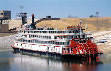
One more steamboat that has a direct connection to Ten Mile is the CLAIRTON. She was built at Ambridge Pa. in 1927 and was 147 x 33 x 6. Originally the called YOUGHIOGENY for Carnegie Steel she was later named the B. F. FAIRLESS. She came to be called CLAIRTON in 1952, being the third and last boat of that name. She ran almost entirely on the Mon till 1964 and was laid up at / near Engles Boat Docks at the mouth of the creek at Millsboro. There was hope she could be utilized locally as a museum but this never came about. While she was laid up there she had a new career as a restaurant for several years. With my family I took a few meals on that old boat . I remember that it was none too fancy but quite clean, everything wood painted white, inside and out. Guests had to ascend to the boiler ( second ) deck for seating in a small saloon. I prowled around her several times on those visits and I fail to remember her having her wheel , it may have been removed. A final chapter to the story is that in 1974 she was sold to a New Orleans company. Her engines , less boilers, were installed in the NATCHEZ, a sternwheel steamboat built new in 1975 for the day excursion trade and those same engines power her in New Orleans Harbor to this day, every day. Some old boats never die.


The CLAIRTON when she was still the B. F. FAIRLESS at the Elizabeth bridge in 1950, shoving coal as she did for 37 years.

December 5, 2008

W.J. Rainey And The Clyde Mines

This is the river tipple at Fredericktown in the late 1920's, looking south. This was the original Clyde mine, opened in 1900.

image from Bower's Fredericktown 1790-1990

Coal came out of this slope portal and went directly to the river tipple as seen in this 1929 photo. Shown are 8-ton gathering locomotives, these gathered the coal cars from various working places in the mine and made up the long trains for the haulage locomotives to pull out of the mine.


The Clyde mines have had several owners over many years. The original ( 1900 ) Clyde Coal Company of Pittsburgh sold their Fredericktown mine to W. J. Rainey of Cleveland, Ohio in 1925. From that point it was a captive mine to Republic Steel. In Pitt Gas, the William Pitt mine had been operating since at least 1916. Owned by the Pitt Gas Coal Company, it was worked by the Trumbull Coal Co. from around 1920. The Rainey company bought it in 1929. They called it Clyde # 2 and enlarged the town of Pitt Gas with the construction of 84 brick and tile houses. The Clarksville Gas Coal Co. operated a mine at Clarksville starting around 1920. At some point in 1925 or later, Rainey bought it and this is what must have become Clyde # 3.
W.J. Rainey, active in the business since the 1880's, owned many large mines. By 1904 he owned 3,200 coke ovens employing 18,00 men. Some of these, with partner T. J. Wood, were operated as the Rainey - Wood Coke Company. Known as the Cleveland Coke King, he was Frick’s main competitor in the Connellsville district. His thousands of acres of coal rights were scattered over the tri-state area . When he died in 1919 he left a fortune worth about 40 million dollars ( equal to half a billion and more in todays dollars ). The company operated under that name for years afterward.


. This porcelain sign likely dates from the Rainey takeover. It's very plain but is one of my most favorite pieces in my modest collection. This is because my father and his father worked together as buddys at # 3 in Clarksville.

So under The Rainey's control, Clyde #1 was at Fredericktown, Clyde #2 was at Pitt Gas, Clyde #3 was at Clarksville. Emerald ( originally Edward Mine, 1921) at Chartiers was called by some Clyde #4 but was since the middle 1920's ( if not always ) owned by the Emerald Coal and Coke Co. ( Hillman ). It seems that Clyde #2 was connected underground with Emerald at least for a time. In 1944 when there was a fire at Emerald ( which took six lives ) causing that mine to be sealed , much of Clyde had to be closed temporarily. In this same year there were about 1260 men employed at the three Clyde mines.
Rainey later ( around 1948 ) sold all these to Hillman Coal and Coke Company. Later they were operated under the name of Republic Steel.
Through this period of time, most commercial coal mines in our area were owned by the same few big dogs, Carnegie, Hillman, Rainey , H.C. Frick, the Jones brothers and a very few others. The Mellons were involved in the Pittsburgh Coal Company and had been working with H.C.Frick since the late 1870's. The names , on paper, moved back and forth over the years. The coal at a certain place was Rainey's , but Emerald mined it, at some point Hillman bought the coal from Rainey, or from Emerald , or whoever, and then Hillman mined it.


Blasting Cap Token From Clyde # 2 in Pitt Gas, my collection


1925 Map from Monongahela Railway 1903-1993, Gratz and Arbogast

Aerial view of Pitt Gas and Clyde # 2. The coal wagons came out of the slope three at a time and crossed the creek on a bridge to where the railcars were loaded. It looks as though the loading of cars here had stopped by the time of this 1939 photo. Gone too, are the railroad yard tracks. The tall concrete pier from the tipple still remains today beside the modern road.


This is Clyde #3 at Clarksville, looking south. The cars are marked for the Rainey-Wood Coke Company in this 1937 photo from the Mononghela Railway.


Aerial view of Clyde # 3 in 1939, tipple and cars underneath, the swinging bridge and the mine shop buildings. The slate dumps are behind the row of miners houses we called Shantytown. A mine track comes out of the tipple and curves around as it crosses over the Besco road and runs to the slate dumps south of the mine. Aerial images courtesy of Penn Pilot.


Clyde # 3 looking west, likely in the 1930's, photo courtesy Of Hoyle Family


2009 image by author

The Clyde # 3 site today, looking west. The swinging bridge is behind the photographer. The above tipple was in the center of this photo. The stables were to the left, near the underpass, against the track embankment. The piece of paved road in the foreground is part of the original road. To the left on this side of the old road were several frame houses that the company built for bachelor miners.


A very partial list of miners who worked in Clyde can be found here.