Showing posts with label Besco. Show all posts

October 13, 2009

1939 Aerial Survey Photos - Mouth Of Ten Mile To Waynesburg


A reader sent me a link to a most interesting site called Penn Pilot - Historical Aerial Photographs Of Pennsylvania. It seems that on several occasions the entire state was photographed from the air for geological survey research purposes. Different groups of images were made from the 1930's through the 1970's. They are reproduced on a Penn State University website. Shown here are a group featuring Ten Mile Creek from the mouth at Millsboro to Waynesburg in 1939. If you want even closer views, go to the site itself, download the largest versions of the ones you want, if you use Windows , view them then in Windows Media. They open to very large photos : bridges, farms , coal mines , towns, steamboats on the river, to me it's fascinating stuff. In the future, I plan to take a closer look at some of these images and describe what I notice of their content.

The mouth of Ten Mile showing Fredericktown, Millsboro, Besco and Pitt Gas


Clarksville To Chartiers


Pollocks Mill, Jefferson and Mather


Waynesburg and east


September 22, 2009

On Coke Ovens and The Fayette County Exodus


Coke ovens at Poland Mines 2009 courtesy Of SWPA Rural Exploration

In the Ten Mile Creek area, Marianna, the Champion Mine at Besco, Dilworth at Rices Landing and Poland Mines # 2 all had coke ovens operating at one time or another. At most mines, a coking operation was set up as an adjunct to the mine, most mines producing more coal than they could process to coke. At Besco, with 257 ovens, the entire output was made to coke and shipped out that way. All coke ovens on this side of the river were of the beehive type as were the majority in western Pennsylvania. The later rectangular ovens were invented by W.J. Rainey engineers starting around 1905 and were adopted at a dozen larger works in the Connellsville and Klondike regions. This type was more mechanized and required higher labor skills. The final answer was using by-product ovens that captured all the gasses for use and brought the coking process to it's ultimate efficiency. This kind of operation was done best, not on site, but in large, dedicated works like the Clairton Coke Works, opened in 1918 and still the largest in the world. In the 1970's and 80's, the company I worked for, Ohio Barge Line, had at least 5 big boats moving coal from Kentucky to feed the ovens at Clairton, each boat bringing over 22,000 tons a week. There were dozens of other boats, all towing coal to there from out of the Mon, Allegheny and Ohio river mines.
By-product ovens outpaced beehive ovens by 1919 and eventually replaced the beehive ovens in the region by 1925, although some continued to operate as late as 1960.

Many older folks remember the way the nighttime sky would be lit up from the rows of ovens. I remember, as a child, seeing the glowing ovens of Alicia reflected on the river above Brownsville as we drove up the river road.


In the early decades of the last century as the new mines opened in Washington and Greene counties there was what I choose to call an exodus of sorts from the Fayette county mines. Many folks in the Ten Mile area can trace family roots back to Fayette county patch towns. Modern patch towns with indoor plumbing, electric lights, porches, general improvements to roads and grounds must have been part of the attraction as well as the idea of starting out a new life in a new place. Mather , Crucible, Richeyville and Marianna with their movie houses, ice cream parlors, ball fields and playgrounds, all built by the company, looked pretty good to these, many of them first generation Americans, coming from the old worn out patch towns to the east. Marianna's and Clarksville's ( Williamstown ) brick homes even had basements, unheard of in most older patches. Also, some of the older mines were being played out after many years of mining. Modern technology was already beginning to displace workers, more mechanized mining and coking meant the loss of many jobs. A lot of young men, miners already themselves, took the opportunity to strike out from the old family home to start a new life on their own in a new patch.


Map Courtesy Of coalcampusa.com

My Grandfather worked in Fayette for several years at East Millsboro for Hustead-Semens and moved to Clarksville in 1924 to finish his mining career in Clyde. All three of his sons became miners, two of them for their entire lives, my father in Clarksville and my Uncle George in Richeyville. My maternal grandfather worked in a lot of different mines. Arriving from the Tatra Mountains region of Poland in 1913, he, Thomas Krencik, went to work in a Fayette county mine and the next year sent money for boat passage for his wife and daughter. He and his wife Anna had 15 more children, four of which died in infancy. Of these, seven were born in Fayette county towns like Republic, Edenburg, Lambert and Helen. Around 1924 he moved his large family to Marianna, first to a farm and later to the patch. He wasn't finished roaming, by 1937 they were living in Ontario, near Cokeburg, from which mine he retired. By that time , several of his sons who took up mining had moved to Clarksville, Ellsworth, Marianna, Cokeburg and other area towns. Many of the older people that I have interviewed have direct ties to Fayette. Years of reading obituaries have shown me that if you come from this area and your roots go back to a couple generations of miners, odds are good that at least one side of your family came from the county to the east. In this way the already decades old commercial coal and coke industry in Fayette county significantly impacted on the later growth of the Ten Mile Creek area.

The 1850 US Census of Manufactures, the earliest Census reference to coke, listed Allegheny County as the only coke producer in the United States. By the 1860 Census, four counties in the United States that produced coke were listed. It should be noted that the Clinton furnace on Pittsburgh's Southside began using coke as its only fuel in 1859. By 1870 there were estimated to be 1,300 coke ovens in the United States. All of them were beehive ovens and all were in Western Pennsylvania, 1,063 in the Connellsville region alone. Of the 2,752,475 tons of coke produced in the US in 1880, Fayette Co. produced more than 45%. Westmoreland followed with 27%, and Allegheny contributed 3.5%. Combined, the three counties yielded almost 77% of the nation's total. In 1880 seventy-two percent of the nation's beehive ovens were within the same three counties. Connellsville coke was the unequaled fuel of preference for the iron and steel industry by 1890. The peak of Connellsville coke production was in 1916, when there were more than 40,000 active ovens.
Connellsville Coke Region Maps from National Park Service


April 8, 2009

Ten Mile Trivia # 2

Ten Mile Creek came to be called so because it's mouth is ten miles above Old Redstone Fort at Brownsville. In the early days they named creeks and other landmarks as being so many miles from a known place, as Brownsville certainly was in the early days. Islands also took mile marker names, for instance above Louisville Ky is 18 mile island then 12 mile island and then 6 mile island.
Some think the creek was named so because it's ten miles long. Not true, but ten miles up the creek is located the town of Ten Mile. Its Indian name is Cusuthee.
.
The very first steamboat to travel to New Orleans and return by its own power was the ENTERPRISE, designed and built in the Brownsville boatyards and launched from the Brownsville Wharf in 1814.

"Saint Barbara , the patron saint of miners, was a young virgin who defied her father and decided not to marry. Because of this he kept her in a tower. She ordered some workmen to alter the tower while her father was away, thus becoming the saint of architects. After finding out about this her father chased her to the hills where she was swallowed up by the hill. Her name is attached to Santa Barbara, California. There is a prayer for miners dedicated to Saint Barbara:
"As I now descend into the dark bowels of the earth, I beseech thee, sweet Barbara, that I be kept safe from harm, for it liketh me not that I rush unbidden into God's presence."

Wilson's Port, later called New Geneva was a very early place for freighting flatboats and rafts.The land later was patented by Elias Stone and his wife in 1787 and was called Delight.


Augustine Dillner and his wife were the first settlers in what is now Greene county.They arrived as early as 1754 and in 1755 built a cabin close to Crow's Ferry ( Dillner ). The Indians were friendly with them till Lord Dunmore's war of 1774.


"While making a tour of the United States in 1837, General Santa Anna, President of Mexico, stopped in Washington Pa.on January 15. Following the custom of the time, he probably took breakfast at Hill's Stone Tavern ( now the Century Inn ) in Scenery Hill, Pa. This was only a year after the massacre of the Texans at the battle of the Alamo, and Santa Anna was not very popular, so there was no reception committee. All known of this visit was the mere mention in the local paper, The Examiner of his passing and a well grounded tradition that a local man named Brice, whose brother had drawn a black bean ( died ) at Goliad, lay in wait just west of town to take a pot shot at the self styled "Napoleon of the West" as the stage rolled by. Fortunately for Santa Anna the sheriff heard of the plot, and, probably against his personal inclination, gathered Brice into his official fold until the Mexican was safely through Washington. Incidentally, Brice was a dead shot, and might have saved the United States much trouble nine years later if the sheriff had let him alone."

Hills Tavern now Century Inn


UMWA LOCALS
6330 Chartiers
688 Clyde
4583 Clarksville
6151 Mather
6290 Nemacolin
6310 Greensboro
4731 Crucible

6159 Bobtown
762 Vestaburg
2300 Waynesburg

UMWA Band of 4583 Clarksville Stanley Fowler Collection

One of the most notable early teachers in Fredericktown was Jonathan Knight. He was later one of the most eminent engineers of his day and became Chief Engineer of the Baltimore and Ohio railroad. He was the inventor of the coning of RR car wheels so that cars stationary on their axles can run on curved tracks without spreading the rails. He surveyed a line ( never built) for the B&O through Greene County in 1836. He lived in Centerville Pa.


Augustine Dillner and his wife were the first settlers in what is now Greene county.They arrived as early as 1754 and in 1755 built a cabin close to Crow's Ferry ( Dillner ). The Indians were friendly with them till Lord Dunmore's war of 1774.

In 1826 the Str. REINDEER was the first boat to Morgantown.

"On February 11, 1850, the first steamboat came up the Monongahela River to the little town of Fairmont. This boat was the GLOBE owned by a man named Yeager. Its appearance created a great sensation among the people, for the majority of them had never seen a steamboat, much less had one come up to their very doors. When it became known throughout the country that a steamboat was to come up the Monongahela River at daybreak on February 11, the people for miles around gathered along the banks of the river as early as the afternoon before. When the whistle of the Globe was heard down the river, the courthouse bell was rung for two hours. The people had brought lunches, so they took the day off as a holiday; speeches were made, and the new wonder examined. Many of the citizens had a free ride up the river. That day was long to be remembered." It was two years before another boat arrived.


In 1856 slackwater, meaning locks and dams, were completed up to New Geneva, making navigation possible nearly year round.

Dry Tavern was named so because in early days there was a tavern there with no liquor sold. It was on the main road leading south between Pittsburgh and Virginia. For years it was the busiest north - south road west of the mountains. The road was laid out by John Crawford and went from Pittsburgh to Finleyville, Bentleyville, Beallsville, Millsboro, Charmichaels, Willow Tree, Rosedale to Morgantown. It was planned to be 60 feet wide.

Ruff Creek got it's name from an Indian named Ruff who lived there.

The first telegraph line in Greene county was erected from Rices Landing to Waynesburg in 1861.


Southwest Pennsylvania was claimed by the districts of West Augusta, Virginia and by Westmoreland, Pennsylvania. In 1776 West Augusta became Ohio, Yohogania and Monongalia Counties, in Virginia. . Greene County in 1776 was partly ( the western slope ) in Ohio county Virginia and partly ( the eastern slope ) in Monongalia County Virginia. The court house for Monongalia was near New Geneva Pa. on the farm of Theopolis Phillips. The court house for Ohio county was at West Liberty W. Va. Virginia law directed that at each court house there was to be a pillory, a pair of stocks, a whipping post and a ducking stool ( now called waterboarding ). Only the ducking stool was used for women.
By 1780 Virginia and Pennsylvania settled their boundary dispute placing most of the Yohogania County region in Westmoreland County. In 1781 Washington County was created from Westmoreland County. Greene County was created from Washington County in 1796.


Before the big modern dams you could at times cross the mouth of Ten Mile Creek by skipping from rock to rock. Other times, because of the volume of water coming out of the creek a very large sand bar would build up there and the river channel would have to be dredged for boats to pass.

Besco is named for the Bessemer Coke Company who operated the Champion mine there using all the coal to make coke in it's 100 ovens . By 1914 there were 257 ovens, a sizable operation. The railroad reached Besco around 1911 and that was the end of track until it was extended farther through Clarksville to Mather in 1919.

In Common Pleas Court in 1797, the following case was considered : The Sheriff of Greene County wishes Richard Swan to answer the charge that he bit off a piece of John Moore's ear thereby damaging the peace and dignity of the Commonwealth.

February 23, 2009

Steamboat To Clarksville and Other Boats On Ten Mile Creek

There are a few documented instances of steamboats on Ten Mile Creek. The month of July in the year 1888 saw what was one of the biggest floods ever on the Monongahela. At Brownsville in that year the river crested at 43 feet, the all-time high water mark there. This was three feet more than even the great flood of 1936. On the crest of this 1888 flood the sternwheel towboat WILLIAM WAGNER ran up Ten Mile Creek and landed at Clarksville. The boat was built at Pittsburgh in 1882 and was 100 x 17 x 2 feet. This was a good sized boat, much bigger than the few steam yacht / pleasure boats that are known to have travelled up our creek. There would have been no bridges to deal with at that time until they reached Clarksville, a little less than three miles from the river. Judging by the configuration of the creek it must have been some hard shoving once up to the area where Pitt Gas and Besco would later be. The vessel was owned By Capt. J. C. Cooper ( called Clinton by his friends ) and Levi Barker. Capt Cooper was in command on this trip. What business they had there, if they had a barge in tow or where at the town they landed is unknown. At that time some towboats running in backwater trades also carried a limited number of passengers, even a small 60 foot boat could be registered for 5 cabin and 5 deck passengers. It is possible too, that they did it just for bragging rights as that was sometimes done by these early rivermen. According To Capt. Way's Steam Towboat Directory the boat was " principally remembered as towing timber out of the Upper Monongahela to boatyards and elsewhere." She was out of documentation ( no longer operating ) in 1890. No photographs of her exist. Capt. Cooper's daughter, Mrs. Phil Kussart, is the author of a river history book titled " The Allegheny River . "

Another boat that visited Clarksville on a flood was the little steam propeller yacht GAZELLE. Nothing is known of either her business or the year she went up. She was 65 x 10 x 3 and built by R. C. Price at Allegheny ( now the North Side of Pittsburgh ) Pa. in 1901. At that time she was owned By Harrison P. Dilworth and other Greene County businessmen who had coal properties on the upper Monongahela. On the trip to Clarksville she was under the command of Capt. John S. Faddis who was, I believe, from the Rices Landing area. He was a riverman of some versatility. In 1905 Capt. Faddis was Master of the ROSE HITE, a large ( 155 x 28 x 4 ) Mon river packet boat that ran the upper Mon. He was at the wheel when she collided with the towboat JOHN F. KUEN above Brownsville and sank with the loss of 5 Black deckhands. He also ran the small DAISEY, a " daylight short trader " , between Martin Pa. and Morgantown early in the century. She was a little sternwheel packet , 75 x 14 x 2 with one boiler that was 54" x 7 feet, built at Antiquity Pa. in 1903. Originally built by Capt. E. E. Varian, she was later owned by H.E. and T. B. Eberhart. In 1908 she was sold to Capt. William Goudy of Rices landing and in 1911 she was sold down the Ohio River. No photo known to me exists of this boat. The GAZELLE probably looked somewhat like the HAZEL L. WATSON in the picture below.


This photo shows the little propeller steamer HAZEL L. WATSON running between East Millsboro and Millsboro with the Mouth of Ten Mile Creek in the background. This photo was taken after 1907 since we see the RR bridge across the creek's mouth. This is an old real photo post card view that I bought years ago and likely one of a kind as those often are. The writer of this card describes it as "the ferry", more accurate would be the old term packet boat or the modern term water taxi. It is likely to assume that she made occasional trips into Ten Mile, water permitting. She was built at Allegheny Pa. in 1901 and was 70 x 10 x 3. Owned by Capt. John O. Watson in 1907, Capt. William Syphers of Rices landing bought part interest and owned her outright by 1909. Syphers, who owned the Monongahela Hotel in Rices Landing, ran her between Brownsville and Rices Landing. Later owned by Crosan Construction of Brownsville , she was lost on Feb. 10, 1918 in the big ice of that year , at Rices Landing.
Ten Mile Creek did, and still does put out quite a volume of water. In old times before the new locks a bar would build up running across the river at the creek's mouth and had to be regularly dredged so that boat traffic could pass up and down.

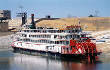
One more steamboat that has a direct connection to Ten Mile is the CLAIRTON. She was built at Ambridge Pa. in 1927 and was 147 x 33 x 6. Originally the called YOUGHIOGENY for Carnegie Steel she was later named the B. F. FAIRLESS. She came to be called CLAIRTON in 1952, being the third and last boat of that name. She ran almost entirely on the Mon till 1964 and was laid up at / near Engles Boat Docks at the mouth of the creek at Millsboro. There was hope she could be utilized locally as a museum but this never came about. While she was laid up there she had a new career as a restaurant for several years. With my family I took a few meals on that old boat . I remember that it was none too fancy but quite clean, everything wood painted white, inside and out. Guests had to ascend to the boiler ( second ) deck for seating in a small saloon. I prowled around her several times on those visits and I fail to remember her having her wheel , it may have been removed. A final chapter to the story is that in 1974 she was sold to a New Orleans company. Her engines , less boilers, were installed in the NATCHEZ, a sternwheel steamboat built new in 1975 for the day excursion trade and those same engines power her in New Orleans Harbor to this day, every day. Some old boats never die.


The CLAIRTON when she was still the B. F. FAIRLESS at the Elizabeth bridge in 1950, shoving coal as she did for 37 years.

November 26, 2008

Steamboat Gallery # 1

No steamboats ran regularly on Ten Mile but they ran right past and besides that ........ I love a steamboat. For about 80 years the easiest and cheapest way to get from Ten Mile Country to the big city ( Brownsville or Pittsburgh ) was to take the packet boat. There were actually only two choices, a mud road or the packet boat until the railroad was extended from Brownsville through Fredericktown to Rices Landing ( completed Jan.9,1908 ) and the branch to Besco, in late 1907. Many towboats and packets were seen every day from the banks and people knew them even at night by the distinctive sound of the whistle.
Here are just a few vessels that were very well known to people on our stretch of the Mon.

The Clyde Coal Co.'s very pretty towboat. Imaginatively, she was named CLYDE
. This company had the mine of the same name in Fredericktown. Built at Rochester in 1903, she ran the Mon until 1930.


The Str. JAMES E. LOSE was one of many Carnegie Illinois Steel Co. boats. Later, these boats that ran locally (in the pools between the dams) were called pool boats , were operated under the U S Steel name and the " line haul boats ", which ran down the Ohio and Mississippi Rivers became Ohio Barge Line ( 1941- 1985). When I started at OBL in the mid 1970's many of the Mates, Pilots and Captains that I worked with had been deckhands and Mates on these Carnegie Steel boats.
In 1945 there were as many steam sternwheel boats operating as there were diesel boats. In 1949 there were still 42 sternwheelers ( J&L alone had eleven of them ) running on the Allegheny Mon and upper Ohio. By 1953 there were 10, five owned by US Steel, Consol Coal and Crucible each still operated two and Ohio Barge Line still had one sternwheeler working. OBL 's last steamboat, a steam propeller vessel, ran until 1963. History is not that far behind us, just look over your shoulder and there it is.


This is the Str. La BELLE of the Wheeling Steel Corp. downbound at Fredericktown.


The CHARLES R. COX of US Steel downbound at Rices Landing. Her roof bell is now on display at the Monongahela River Buffs Museum


The Str. ADAM JACOBS at Brownsville in 1895. Owned by the Pittsburgh Brownsville & Geneva Packet Co. she regularly ran between these places. She was built at Brownsville in 1885.
This was one huge boat, over 200 feet long. Click on the pic and it will enlarge to actual size.......... just kidding.

The W.P.Snyder Jr. at Marietta

Fortunately for us there is a wonderfully preserved example of a Monongahela River towboat at Marietta Ohio. The Str. W.P. SNYDER JR. is docked there at the Ohio River Museum. The museum has a large and fine collection of river artifacts but their jewel is this vessel. She is exactly as she was in the old days and you can wander over her at your own pace and see how they lived and worked on the river on this Carnegie Illinois and later Crucible Steel owned boat. I'm glad they saved one of these unique vessels, she is the only surviving coal-fired, steam-powered sternwheeler towboat in the US not to mention the only pool boat. The smoke stacks on all the pool boats were made to be tilted back to clear low bridges and the pilot house was built on the forward end of the cabin rather than on top of the roof. They evolved to fit the needs of the river and locks in terms of power, size and draft. In the late 70's my wife and I first visited this boat at the museum. When I returned to work I was on the boat with Captain Leon Lyle of Pittsburgh, originally from Paducah, Ky. I had worked with him when he was a mate and he was of the old school and was as good a boatman as could be found on the river and I learned much from him. I was talking about how fascinating it was to visit the SNYDER. he said to me " I know that boat very well, I spent 10 years as Mate on her, just like you are Mate on here for me now. " For a complete description refer to her National Historic Landmark Nomination here.

Starboard Engine


The galley, not a lot of space to prepare food for 12 - 15 people.


The Str. W. P. SNYDER JR. was originally built as the Carnegie Steel Co. towboat W. H. CLINGERMAN in 1918 by Rees of Pittburgh, Pa. In 1938 she was renamed J. L. PERRY and in 1945 she was sold to Crucible Fuel Co. and again renamed as the W. P. SNYDER Jr. She towed coal on the Monongahela river for 35 years until she was laid up on September 23, 1953 at Crucible, Pa. In the summer of 1955 she was given to the Ohio Historical Society for exhibit at the Ohio River Museum of the Sons and Daughters of Pioneer Rivermen in Marietta, Ohio.


November 21, 2008

Sandy Plains And The Fairground


The fairground at Sandy Plains was a popular spot at the turn of the century. Cars and horses / buggy's can be seen. The Fair was first held in 1874, as many as 4,000 people attended in some years. It's hard to believe that there was this much activity there once. Opposite the entrance to the fairground was a large frame house that was for years operated as a hotel.
When I was growing up in the early 60's, we used to ride our bikes up from Clarksville to Ram Hardin's garage across the road from here and rent go carts to ride around the old racetrack. A baseball field was long in use there.


The last four images above are from the collection of Bill Hess of Millsboro

Sandy Plains was originally known as Racine, the name of the post office near the center of East Bethlehem Township. Among the first three original settlers of Washington County was Eberhart Hupp ( died 1824 at age 109 ). Most early history books on Washington County, Pennsylvania refer to the Hupp Family. Reports differ as to just when the Hupps came to the fork of Ten Mile Creek and the Monongahela River. The older published Washington County histories (Creigh, Crumrine, McFarland and Forrest) agree that the Hupps, Bumgarners and Teagardens were the earliest "recorded" (filed for land titles) settlers in the region. Crumrine says that Everhart Hupp, George Bumgarner and Abraham Teagarden came from Virginia together to the mouth of the Ten Mile Creek in 1766. He cites a specific grant of land to Hupp in 1766. He bought the land from the Indians for the sum of " one black mare and one rifle gun." These were later surveyed as Hupp's Regard (387 acres) and Hupp's Bottom (295 acres). The land begins about a quarter of a mile north of the Ten Mile Creek bridge on Route 88 near Millsboro, extending back into the hills to the north and west. Included is the present town of Besco and part of the hills above, up Hog's Hill road to Sandy Plains. Forrest says that Hupp built a blockhouse on the land in 1769.
Russell Bane, a descendant of the Hupps and Millsboro resident, believed that Everhart Hupp's cabin was on the high hill by the Route 88 bridge over Ten Mile Creek. This was in later years known as "the Point". Everhard Hupp's Mill is believed to have been on Black Dog Hollow. Everhard later purchased two tracts of land farther up Ten Mile Creek near the present village
of Ten Mile.
His wife Margaret was the first white woman west of the Monongahela River, she died at the age of 105.

The Mather Train Station And The Chartiers Southern Railway

The Mather station is actually in Jefferson, was built in 1919 and still looks pretty good today. It, while not being " preserved " is not deteriorating. Now that the leaves are gone I can see this building from my window.
The railroad that built it was the Chartiers Southern Railway, owned jointly by the Pennsylvania, Baltimore & Ohio and New York Central Railroads. It became part of the Monongahela Railway in 1926. It was of two disconnected branches, one between Besco and Mather ( finished 1919) and the other between Crucible and Nemacolin ( finished June 7, 1920 ). This image was taken by the Monongahela Railway in the 1930's, looking northwest. Partly visible is one of the PRR gas electric cars that later ran for mail, freight and light passenger service. All the equipment that ran was PRR or Monongahela Ry's. CS Ry never had their name on any engines or rolling stock. This was a rather large station for the line, at Clarksville there was only a small open sided shelter built to accommodate passengers. I have an original blueprint of this building dated 1919, it was Nov.1,1919 that the railroad reached Mather. This was the end of the line until track was opened to Waynesburg on Jan.1, 1930.
Just south of here, near Stoney Point, the track branched off and crossed Ten Mile on an iron bridge and on into the Mather Mine.

Mather Station March 2009, looking good for 90 years old, image by author


This 1922 map shows the two parts of the CS Ry with the track ending at Mather. Shown also is the proposed track connection with Marianna at Clarksville. This, never built, was to follow Ten Mile's north fork along the Washington County side, past the Yablonski house to Pump Station and on to Marianna.